One boundary, all products
Draw the field in the app, or draw/import it in the Geo-Surface owner portal, then run imagery, DEM, and drainage mapping together or pick only what you need.
Surface drains, pads, terraces, slopes, land-forming, tile, trenches — the best RTK grade control and guidance, at the most affordable price. No subscriptions.
Ditch Assist is an RTK/GPS grade control and guidance system for farm drainage, land-forming, and excavator work — one Android app, every mode included, no subscription.
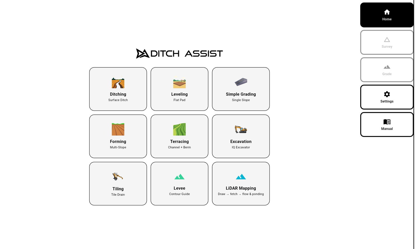
Tap a mode below — every workflow runs on the same Android-based interface, on the same tablet, with any compatible RTK source. The Automation Kit drives blade hydraulics where automatic control is needed; the Guidance Kit gives on-screen feedback; Ditch Assist DIG™ guides the excavator.


Ditch Assist automates scrapers, ditchers, and blades to get surface drainage right the first time. Move less dirt with Slope-IQ™ Best-Fit — or fully customize your design with the most capable toolset in the industry.
New: LiDAR Drainage Mapping — on-demand flow and depression maps for any field, saved to your device and overlaid live on the in-field map.
Ditching →

For maintaining or constructing wide-base terraces — the kind you farm right over the top. Drive to survey the channel, then the berm. Ditch Assist designs the channel to its outlet (grassed runway or tile inlet) while balancing cut and fill so the berm builds to height. Verify berm height as you go.
New: Auto-Balance in the Slope-IQ™ Terrace Designer — adjusts channel cut depth automatically to balance with berm fill.
Terracing →

Create variable-slope and all-way land-forming designs in software like OptiSurface™, Ezigrade™, or Topcon™ AGForm-3D™, then implement with Ditch Assist. A high-quality on-screen cut/fill map keeps you oriented while Auto-Nudge™ manages pass-to-pass cut depth.
Design import: AGD, LandXML, and XYZ/XYZP surface support bring popular ag land-forming designs into the cab for drive-to calibration in the field.
Land Forming →

Two modes: dial a slope and drive — no survey, no design dialog — or survey a centerline through an area, fit a grade to the terrain, then drive outward. Ditch Assist holds the design at every offset, building a plane across the whole area.
Best for: the fastest path from arrival to graded ground — a simple drain, or a minimal-slope plane like flood irrigation.
Simple Grading →

Survey the proposed tile run, then design with Tile-Best-Fit — best-fit or custom placement inside your min/max depth and grade parameters. Install uphill from the outlet with Required Start Depth in view.
Automatic Rock Hit Recovery: when sustained plow ride-up is detected, Ditch Assist applies a bounded target nudge so the controller does not dive back toward the original target and put tile off grade.
Tiling →

Set the blade as your reference height — or enter a GPS elevation — and Ditch Assist holds the implement at that level wherever you drive. Ideal for pulldozers and land levelers.
Best for: prepping ground for building and equipment pads — farm buildings, grain bins, machine sheds, and equipment yards.
Leveling →

Get the field's elevation surface — drive it, drop in a GeoTIFF, or fetch public LiDAR where coverage is available — and Ditch Assist draws every contour. Pick one and drive it; a lightbar and on-map arrows keep you on the line. Guidance-only workflow for paddy dikes, contour berms, existing ridge top-up, and conservation work.
Required hardware: runs on the Guidance Kit or another Ditch Assist control module. No automation valve or hydraulic plumbing required — the blade stays in the operator's hands.
Levee →
Ditch Assist DIG™ brings accurate, real-time grade guidance to any excavator or backhoe through the Ditch Assist app. RTK GPS and smart sensors display live cut/fill guidance that responds instantly to bucket movement, from quick grade and level work to Slope-IQ™ design, mapping, file import, job recording, and resume.
Move between machines: save up to 10 calibrated machine profiles. Weld the sensor brackets on each machine once, then recall the right profile instead of remeasuring and recalibrating every time.
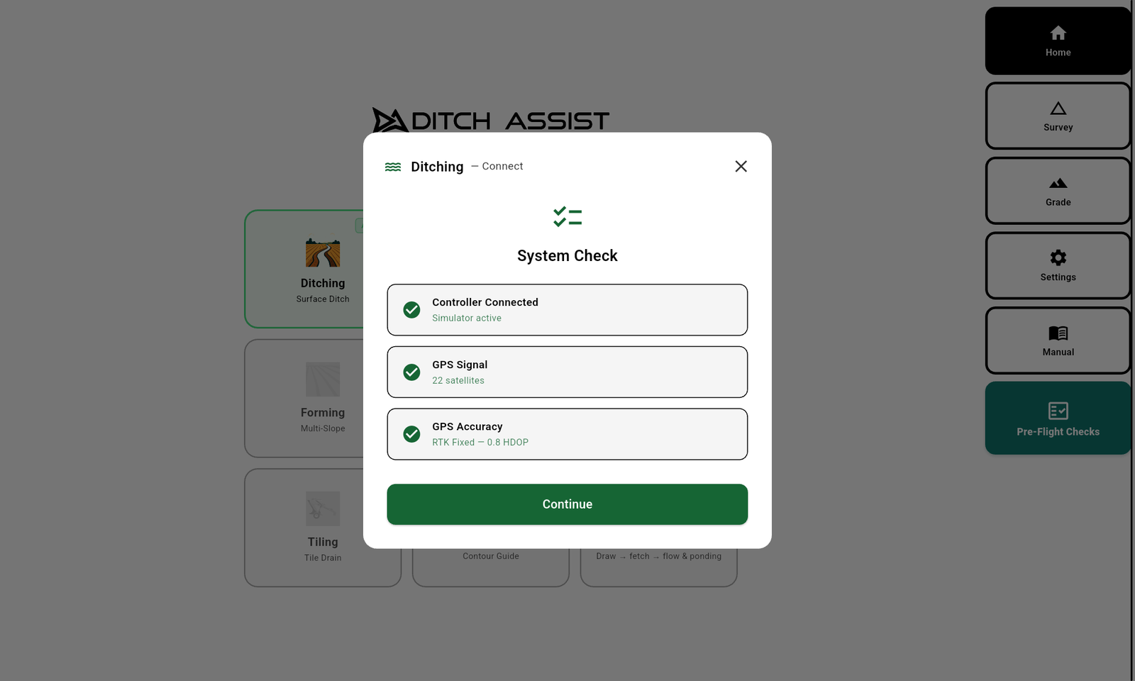
Excavator →Watch the first-run workflow: unlock LiDAR & Mapping with a control module, prepare fields while internet is available, then connect in the cab and verify controller, RTK GPS, and hydraulic control before choosing a mode.
Connect to a Ditch Assist control module once so the app can enable field preparation tools.
Fetch LiDAR, build flow, depression, and ponding layers, and cache satellite imagery for offline field use.
Join module Wi-Fi, confirm the controller connection, verify valid RTK GPS, and check hydraulic control.
Once the system checks pass, choose the workflow that matches the machine and the job.
Next, open the workflow page for your job. Mode pages are where job-specific walkthroughs and operating details belong.
Most of the modes above start the same way: drive the route, Ditch Assist designs the grade. That's Slope-IQ.
Automation when you want it, control when you need it.
Wherever you survey a proposed route, use Slope-IQ™ to design the perfect grade — right from the cab. Customized for each job type, with the tools and information you need to get it right the first time.
Set your minimum grade and let Slope-IQ™ solve the design — it follows the natural slope where it works, cuts through any humps that hold back flow, and moves the least dirt possible to reach final grade.
Anchor grade-break points along the run and let Slope-IQ™ connect them — creating same-grade segments that enforce your minimum grade, ideal for excavation work or balancing cut and fill.
Complete control when you need it — tap anywhere along the run to drop anchor points, then drag them with your finger (even off grade). Whatever you design, Ditch Assist implements.
A drainage ditch, terrace channel, or pad on a sloped site often needs multiple passes to reach grade. Ditch Assist figures out the depth of each pass for you. That's Auto-Nudge.
Most grade jobs need more than one pass — and figuring out depth for each pass is a job in itself. Set your max cut and Auto-Nudge™ computes the target depth for the current pass. Drive it, tap to advance when ready, and watch the profile update to show exactly how much further you've got to final grade.
Configure the deepest single-pass cut your implement and conditions can handle. Auto-Nudge™ respects that limit on every pass.
Auto-Nudge™ computes the cut depth for the current pass — never more than your max. The profile updates so you see exactly how much is left to final grade.
When you're done with the current pass, tap to advance. The system sets the next target, the profile updates, and you keep cutting until you're on final grade.
LiDAR & Mapping works in the app and through the Geo-Surface owner portal: draw or import a field boundary, fetch LiDAR, and prepare the drainage context before field work.
Satellite cache, saved LiDAR DEMs, drainage maps, and Geo-Surface owner portal access — ready before field work.*
Use Prepare Field in the app to cache satellite imagery, save LiDAR DEMs, and generate flow, ponding, and depression layers. Use the Geo-Surface owner portal in the office to draw or import boundaries, generate the same drainage layers, and save geo-referenced images for Ditch Assist map references.
* Subject to public LiDAR availability — full US coverage; in Canada, major ag regions of Manitoba, Saskatchewan, and Alberta, with coverage expanding.
Draw the field in the app, or draw/import it in the Geo-Surface owner portal, then run imagery, DEM, and drainage mapping together or pick only what you need.
Cache satellite imagery and reference labels before leaving internet coverage, so field maps still have context on controller Wi-Fi.
Save the raw LiDAR surface to the tablet for offline contour generation, Contour Tiling, Contour-Guided Terracing, and elevation checks.
Generate flow routes, ponding risk, and true depression layers from public LiDAR, then overlay them live in the app.
Ditch Assist owners get complimentary portal access to draw or import field boundaries, fetch LiDAR, generate flow and ponding maps, and save geo-referenced images for Ditch Assist reference layers.
The channels water already wants to follow. Survey the ditch along them and Slope-IQ™ Best-Fit moves less dirt to drain more acres.
The areas that flood first. Not always true depressions, but they hold water and need real drainage — and the Flow Routes layer shows you the way to it.
The true low spots. Drain them, or fill them using this layer to guide where to drop the soil you scraped — either way, standing water never gets a chance to sit.
Contour Tiling and Contour-Guided Terracing use the LiDAR DEM you fetch and save to the tablet in LiDAR & Mapping. Once it is saved, reconnect to controller Wi-Fi and generate contours from that field surface offline. You can also load a driven field survey, GeoTIFF DEM, or point file.
Fetch the LiDAR once and save it to the tablet. Use that saved field surface to follow a tile contour, lay out a terrace corridor, or come back later and add another line.
Drive near the contour your tile should follow. When you start the survey, that contour locks and the lightbar keeps you on it. The route you actually drive becomes the tile design, then the install steers back along that route while the blade holds depth.
See Tiling mode →Pick the contour your new terrace should roughly follow and Ditch Assist paints a Terrace Zone around it. Survey the channel inside the corridor, drift downhill toward the outlet to build fall, then survey the berm and let the Terrace Designer balance cut and fill.
See Terracing mode →Built around the operator in the cab — wizard-led, fully visual, accuracy-managed. Five things Ditch Assist does that make every job simpler and every result better.
Choose the mode that matches today's job. The wizard walks you through every step — no manual to read, no training day to schedule.
See the terrain as you survey, the cut depths and volumes as you design, and your live position against the final cut as you implement. No guessing — at any step.
Detects sudden accuracy losses, omits suspect points from surveys, and smooths jumps when grading. Major RTK loss stops the system. Quick glitches? You won't notice.
High-contrast screens you can read at a glance. Big buttons where you need them. Layouts that put every key action one tap from your thumb — no menu hunting, no second-guessing.
Download the Ditch Assist Android app direct from our website. One-time purchase, no subscription, no per-machine activation — every customer in the current version gets every release.
Saved field benchmarks put every visit on the same elevation reference — drop one at the field entrance, recalibrate to it tomorrow, and resume the job exactly where it stopped, even after the RTK base moves.
Full UI and operator manual in English, Spanish, and Brazilian Portuguese.
Choose Dark or Daylight display and Imperial or Metric units from Settings.
Get the app → See every app feature →Eight things that set Ditch Assist apart from the rest of precision-ag grade control — and the everyday pain points we built the system to solve.
Most systems are over-complicated — difficult installs, confusing screens, features nobody uses. Ditch Assist was built to do what you need it to do, as simply as possible.
Most systems lock you into a single manufacturer's ecosystem. The Automation Kit adds hydraulic control when you want the blade to track grade automatically; the Guidance Kit and DIG keep the operator in control with live feedback.
Most systems only work with one brand of RTK. Ours works with any brand — and where upgrading is cost-prohibitive, our bundled Emlid RTK kits deliver same-or-better performance at a fraction of the price.
Wiring harnesses suck. We can't claim to have eliminated them, but you won't find another system with fewer wires — and wireless implement-to-cab means no wires running inside the cab at all.
Most systems force you to buy their proprietary display or an expensive Windows tablet. Ditch Assist runs on a standard Android tablet — a few hundred dollars, not a few thousand.
Everyone hates them. While other precision-ag companies push subscriptions, Ditch Assist is a one-time purchase. Our earliest customers are still receiving free updates to the latest features and functionality.
Switch Ditch Assist between tractors and implements in as little as 20 minutes. Ditch in the morning, move it onto something else after lunch — customers tell us they couldn't live without that flexibility.
Your success is our success. On-demand LiDAR flow and depression maps right in Ditch Assist — free for every owner. Follow these routes for the best results with the least dirt moved. Nobody else offers this.
The Automation Kit drives the cylinder on any tractor-pulled implement you grade with; the Guidance Kit gives on-screen on-grade feedback while the operator works the hydraulics manually. The DIG™ Kit guides any excavator or backhoe. All talk Wi-Fi to your tablet, work with any RTK GPS, and install in minutes.
The Automation Kit drives the existing raise/lower hydraulics on any scraper, blade, or ditcher so the blade tracks grade automatically. The Guidance Kit displays live on-grade feedback while the operator works the hydraulics manually — no hydraulic valve required. Both kits run every surface-grading mode in Ditch Assist.
Combines RTK accuracy with stick and bucket sensors for accurate cutting-edge grade at any digging position. Excavator guidance runs in the Ditch Assist app, from simple grade and level targets to Slope-IQ™ best-fit, multi-slope, curved designs, LandXML surfaces, and saved jobs.
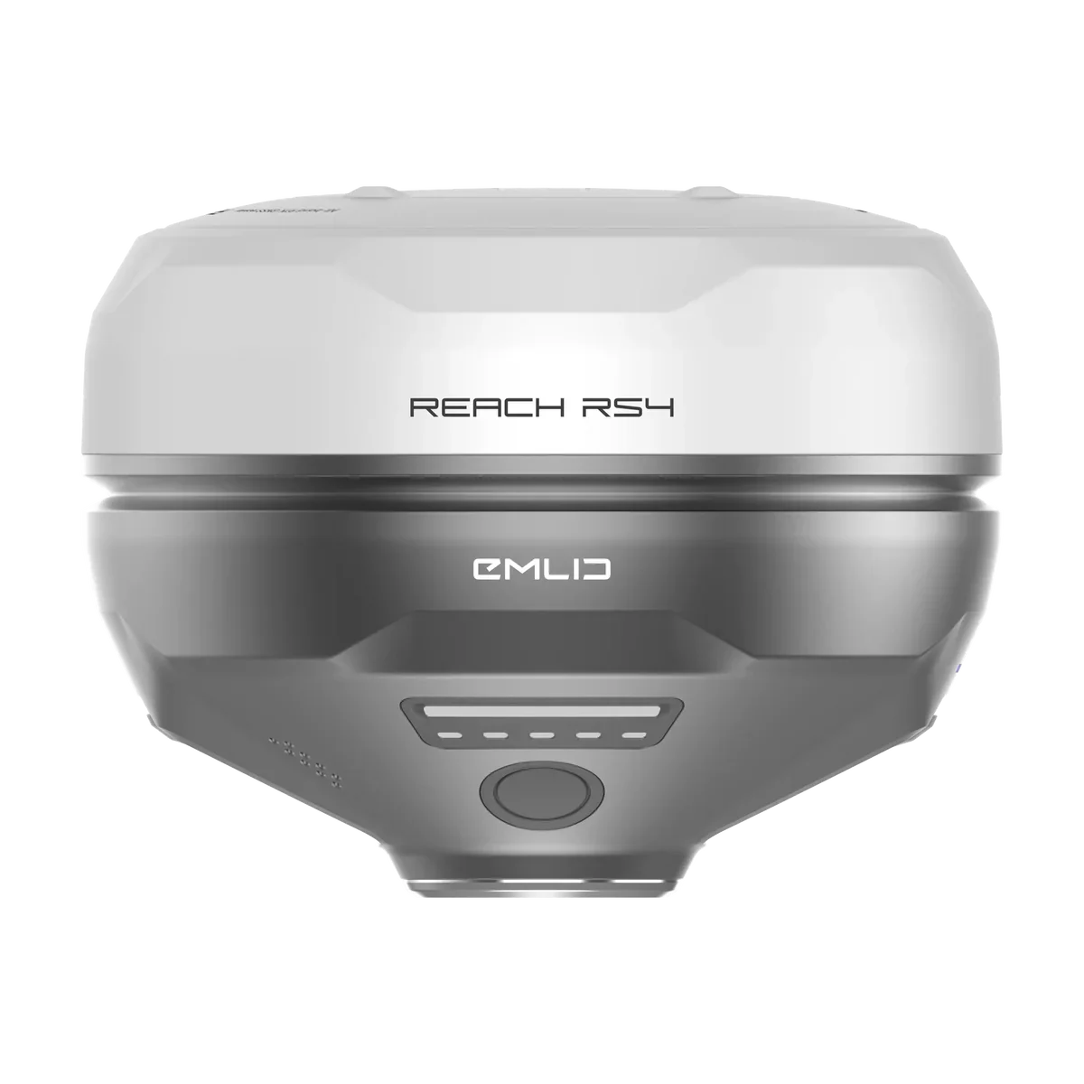
Bring the compatible RTK receiver you already own, or bundle Ditch Assist with Emlid Reach RS4 / RS3 receivers when you are starting fresh. Most customers choose either two RS4 receivers, or an RS4 base with an RS3 rover on the machine. The Ditch Assist-only bundle adds the base tripod, tripod extender, mount hardware, and Ditch Assist-to-Emlid RTK GPS cable.
Emlid is a practical base/rover path for customers who do not already have RTK accuracy unlocked on existing ag equipment, and Ditch Assist can quote it with the needed install pieces.
A local Emlid base and rover radio link lets many customers grade without relying on a paid correction service.
The same Emlid receivers can be used for surveys, benchmarks, mapping, drone base work, and other compatible equipment.
Built by farmers and precision-ag experts tired of grade-control systems that don't think like operators. Ditch Assist drives any tractor-pulled implement, guides any excavator, and works with any RTK GPS — wirelessly, simply, with no subscription. Engineered in Manitoba and supported on the ground in Canada, the United States, Central America, Brazil, Argentina, Australia, South Africa, Japan, and more.
“Looking at the price of known systems for GPS dirt grade control systems, we thought this technology was out of reach for us… After talking with their team, I was almost in disbelief at their technology capability and price point!”
“Seeing my customers save time, improve their work, and come back to tell me how well it’s working is what makes this job rewarding. Ditch Assist is a very simple, affordable system — and ease of training the operator makes it a breeze to support.”
“Oh man, world of a difference. Crazy what that thing can do. Paid for itself pretty quick, especially with this year.”
This is a live browser build of the Ditch Assist app — real screens, real workflows, every mode included. No login, no hardware, no download.