Background:
During October 2023, Northern Plains Drainage Systems Ltd began to unveil online mapping portals. These portals will offer Ideal Drainage Mapping data for Ditch Assist machine control system owners. This guide aims to equip Ditch Assist owners with essential information about this update.
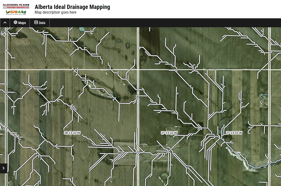
Understanding Ideal Drainage Mapping (IDM)
Ideal Drainage Mapping, or IDM, is an advanced data layer that's pivotal in identifying the optimal placements for land drainage, particularly for surface drains. This data is characterized by line attributes, which represent the natural pathways that water follows across different landscapes. Typically, when IDM features are mapped, they highlight the routes that water naturally takes when draining from the land.
Maximising the Benefits of Ideal Drainage Mapping (IDM)
Ideal Drainage Mapping (IDM) data serves as a valuable tool for gaining an understanding of water flow patterns within fields, providing a detailed overview of regional water movement. This information is indispensable for devising effective drainage strategies and grasping the complex dynamics of water flow in a given area. By aligning your drainage infrastructure with the natural IDM routes, you can achieve more efficient water management solutions that require minimal alteration to the landscape. In essence, tackling drainage issues often involves connecting areas with poor drainage to suitable outlets by following the pathways indicated by IDM data.
Optimising Drainage Strategies with Ideal Drainage Mapping (IDM)
Ideal Drainage Mapping (IDM) data provides invaluable insights into water flow patterns within fields, offering a detailed snapshot of regional water movement. This information is instrumental in planning effective drainage systems and understanding the intricate dynamics of water flow. Aligning your drainage solutions with the natural pathways highlighted by IDM can lead to more efficient outcomes, often with reduced earth-moving efforts. However, while IDM is a powerful tool, it's important to note that its accuracy may vary at the field level. Therefore, it's advisable to use IDM data as a guide, complementing it with on-the-ground observations and professional judgement to ensure the best possible drainage outcomes. By connecting areas of poor drainage to appropriate outlets, using IDM routes as a reference, you can effectively address drainage challenges while remaining cognisant of the data's limitations.
Incorporating Ideal Drainage Mapping (IDM) into Ditch Assist
Integrating IDM maps into Ditch Assist is a straightforward process. Users can select the IDM data relevant to their fields and export this information as a KML file. Ditch Assist offers native support for KML files as map layers, allowing you to overlay the IDM data directly onto your working map. This provides visual guidance and enhances precision when using Ditch Assist in the field. For a detailed, step-by-step tutorial on how to carry out this integration, please visit our instructional page at https://www.ditchassist.com/ideal-drainage-mapping-for-ditch-assist/.
The Formulation Process of Ideal Drainage Mapping (IDM) Routes
The creation of IDM routes is rooted in a sophisticated and proprietary methodology. At its core, this process involves the use of medium and high-resolution LiDAR and satellite-derived digital elevation data. By harnessing the power of supercomputers, this elevation data undergoes several layers of complex processing. This procedure involves filling depressions and then modeling 'fill-and-spill' water flow across extensive regions to accurately determine natural drainage pathways.
Selecting Viable Routes from Ideal Drainage Mapping (IDM) Data
While IDM provides a wealth of potential flow paths, it's crucial to note that in regions like Saskatchewan and Alberta, the use of medium-resolution data might result in some paths following the path of least resistance, which isn't always the most viable option. In certain cases, these routes may require deep cuts, making them less practical. It's imperative to use your judgement when reviewing IDM data. If an alternative route appears more logical and requires less intensive modifications to the land, it is likely the more prudent choice. Trusting your expertise and understanding of the terrain will guide you in selecting the most effective and efficient drainage solutions.
Evaluating the Precision of Ideal Drainage Mapping (IDM) Routes
The precision of Ideal Drainage Mapping (IDM) routes is typically robust, offering a high degree of accuracy at the field level. However, it's important to acknowledge that, due to the broad scale of data modelling, there can occasionally be minor generalisations or nuances that might be perceived as discrepancies.
The reliability of IDM routes can vary regionally, largely influenced by the resolution of terrain data utilised in the modelling process. In areas like Manitoba and North Dakota, we've had the advantage of high-resolution LiDAR data. This detailed data provides a nuanced and accurate depiction of natural water flow paths, enhancing our confidence in the IDM layers produced for these regions.
In contrast, for regions such as Saskatchewan and Alberta, the IDM routes are derived from medium-resolution data. While this data is valuable, its lesser detail can result in water flow paths that opt for the shortest, least resistant routes. These may not always align with the most practical or feasible drainage solutions due to potential requirements for substantial earthworks.
Consequently, when utilising IDM data in Saskatchewan and Alberta, a more judicious approach is recommended. It's wise to marry the IDM routes with comprehensive, on-ground assessments, applying your knowledge of the land and practical considerations. If an alternative route seems more logical or involves less extensive alterations to the landscape, it is sensible to give it due consideration. Ultimately, while IDM provides an excellent starting point, the true value and reliability of the routes it proposes are amplified when they are considered alongside professional insight and judgement.
Discrepancies Between IDM Routes and Municipal Drains
The resolution of our foundational data may not capture all details of culvert locations or municipal ditches, leading to IDM routes not always aligning with existing municipal drains. When IDM suggests routes along field edges, ensure they lead to field-edge ditches, not just run parallel. Additionally, IDM might not align with culvert placements, so it’s important to cross-reference IDM data with actual terrain and infrastructure.
Absence of IDM Routes in Some Problem Areas
Due to the simplification necessary in data processing, some problem areas might not display IDM routes. In these cases, it's advisable to manually connect these areas to the nearest IDM route that logically facilitates drainage.
Reasons Behind Counterintuitive IDM Flow Routes
Occasionally, the large-scale nature of our modelling might result in IDM flow routes that appear unconventional at the field level. Though these routes are part of a broader water flow model, they may seem less intuitive when viewed in isolation. It's advisable to trust your judgement and consider more logical alternatives in these instances.
Reasons for Non-Inclusion of Existing Field Drains in IDM Maps
IDM maps primarily depict natural water flow routes. There are instances where farmers have installed drains that diverge from these natural paths, either by design or inadvertently. Consequently, such man-made drains might not be captured in IDM if they don't coincide with the field's inherent drainage patterns.
Furthermore, IDM's tendency to model water flow along the shortest path or route of least resistance can also play a role. If existing field drains were constructed based on factors other than the path of least resistance, such as avoiding obstacles or leveraging gravity, they may not align with IDM's modeled routes.
Reconfiguring existing drainage to more closely mirror IDM's routes could lead to enhanced drainage efficiency. It might even present opportunities to infill certain deeper, less efficient ditches, streamlining your field's drainage system.
The IDM routes show my water going onto my neighbor’s field. What am I supposed to do now? IDM maps out nature's original water pathways, sometimes crossing property lines as they existed before the current land divisions. While IDM is generally accurate at the watershed level and depicts natural flow within watersheds, it's crucial to remember that you typically don't have the legal right to redirect water onto another person's land in many jurisdictions. If IDM indicates your water naturally flowing onto your neighbor's field, it's important to consider alternative drainage solutions that adhere to legal regulations and respect property boundaries.
When faced with this scenario, you might need to devise drainage plans that diverge from the natural routes indicated by IDM. Although such solutions might necessitate deeper ditches and may not be as efficient, employing precise grade control can help minimize the required depth and enhance the overall effectiveness of your drainage system. Whenever possible, strive to connect problematic areas to an alternative IDM route that remains within the confines of your property, thus preventing potential disputes and legal issues while maintaining effective water management.
Availability of Elevation Data for Individual Fields
Accessing elevation data for individual fields isn't possible through our platform. The sheer volume of data required, alongside the storage capacity needed, renders it unfeasible. To put this into perspective, we're already utilizing storage space equivalent to that needed for over one billion eBooks!
Seeking Alternatives When IDM Flow Maps Are Insufficient
Should the IDM flow maps fall short of providing the necessary level of detail, it's important to recognize that the broad coverage and inherent limitations of resolution and smoothing might be the cause. For those requiring more granular information, alternative solutions such as RTK or drone elevation surveys could be more suitable. These methods can yield much higher resolution terrain datasets than IDM, offering a more precise basis for drainage planning and implementation.
Identifying IDM Coverage for Your Fields
To verify if your fields fall within IDM coverage, consult the detailed coverage map we provide. Our service presently spans the principal agricultural areas of southern Manitoba, Saskatchewan, Alberta, and North Dakota. This map can be accessed directly at https://www.ditchassist.com/ideal-drainage-mapping-for-ditch-assist/.
Future Expansion of IDM Coverage
Our commitment to expanding IDM coverage is ongoing, and we actively seek out reliable data sources in regions frequented by our users. As new data becomes available, we'll promptly update the portal to reflect the expanded coverage areas.
Enhancing IDM Portals with High-Accuracy Data
For users in Alberta, we are now able to provide an option to purchase higher resolution LiDAR data, which can significantly refine the detail and accuracy of the information on our portal. However, please be aware that this service comes with a cost of $500 per township, which covers an area of 36 sections. This fee is necessary to cover the costs associated with procuring and integrating this more detailed data.
We understand that some of our users might have access to their own high-accuracy data, such as drone-derived Digital Elevation Models (DEMs). We're open to processing and incorporating this data into our portals for those fields. However, this is a resource-intensive task that incurs a charge, reflecting the time and effort required to ensure the data is integrated smoothly and effectively.
Contact Us for more information via the contact form on our website.
Additional Uses of the Data Beyond Ditch Assist Integration
Adhering to our licensing terms, which mandate the use of data solely for properties you own or manage without selling or disseminating it in any format, there are several innovative ways to utilise the data:
High-Resolution Printed Maps
The portal enables the creation of high-definition printed maps in PDF format. These maps can serve multiple purposes, including:
- Assisting in permit application processes.
- Acting as supplementary guides during fieldwork.
Sketch Functionality and Custom Designs
Leverage the portal’s Sketch feature to:
- Craft bespoke drainage designs or annotations.
- Export these custom designs as high-resolution PDF maps for printing or as supplementary material for permit applications.
Advanced Custom Design with Third-Party Software
For users with a penchant for further customization:
- Export IDM data in KML or SHP formats.
- Use free software like Google Earth Pro or QGIS, with IDM data as a reference, to devise your own drainage designs.
- Save these personalized designs in KML format and import them into Ditch Assist for execution.
Geolocation Capabilities
Activate Geolocation within the portal to:
- Monitor your real-time location on your mobile device.
- Tip: On Android devices, running Google Maps in the background can enhance location accuracy and refresh rates.
These additional functionalities are designed to maximise the utility of the data and provide you with versatile tools to aid in precision agriculture practices.