Field Elevation + Ideal Drainage Mapping™ for Ditch Assist Users
On-Demand Access to Detailed Field Elevations + Drainage Flow Routes via our web Portal and now also in the Ditch Assist App

High-accuracy Contour Mapping and IDM Flow Routes Now Available For:
- Most areas in Southern Manitoba
- Some parts of Saskatchewan
- North Dakota (entire State)
- Minnesota (all major agricultural regions)
- Iowa (entire State)
Lower-accuracy data is also available for other areas of Saskatchewan and Alberta, offering valuable insights for field drainage and water management
We are currently working on other regions - check back soon
2024 Fall Offer Extended: Ditch Assist Owners get Free Access ($499 value)
Current Coverage Areas
Manitoba Coverage Areas

High-resolution LiDAR-based contour mapping and IDM flow maps are available across all covered areas. Access them via the web portal or download directly to the Ditch Assist App.
Saskatchewan Coverage Areas

High-resolution LiDAR provides detailed contour and IDM data in shaded areas, while other regions are covered by lower-accuracy satellite-based terrain modeling.
Alberta Coverage Areas

All major agricultural regions are covered by medium-accuracy contours and IDM flow maps from the Alberta Provincial Digital Elevation Model, offering a solid general overview of terrain.
North Dakota Coverage Areas

High-resolution LiDAR-based contour mapping and IDM flow maps are available for all locations within North Dakota. Access them via the web portal or download directly to the Ditch Assist App.
Minnesota State Coverage Areas

All major agricultural regions are covered by high-resolution LiDAR-based contour mapping and IDM flow maps. Access them via the web portal or download directly to the Ditch Assist App.
Iowa State Coverage Areas

High-resolution LiDAR-based contour mapping and IDM flow maps are available for all locations within Iowa. Access them via the web portal or download directly to the Ditch Assist App.
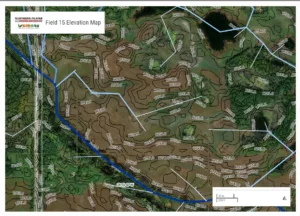
Ideal Drainage Maps
What They Are & How to Use Them

We've Created Optimal Drainage Paths Derived from LiDAR and Satellite Data for over 100 Million Acres!

Use them to Understand Water Movement and Guide Drain Placements for Efficient Water Management

NEW: Download IDM and field elevation contour layers directrly into the Ditch Assist App and access in the field
When you sign-up we'll send you detailed instructions to download IDM and Contour Maps right into your Ditch Assist App, as well as a link to setup your Portal login access

COMBINING TECHNOLOGY WITH INSIGHT
Use Ditch Assist with Ideal Drainage and Contour Mapping for Ultimate Results
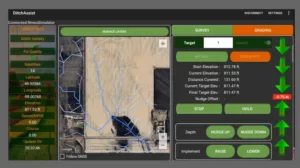
Struggling to determine where to place your drains or unsure if one end of your field is higher than the other? Ditch Assist and Ideal Drainage Mapping make it easy. Our advanced drainage and contour mapping provide crucial insights into water flow across your fields—far beyond what you can see with the naked eye. With the Portal, you can view, print, and create custom sketches, plus download IDM and contour layers directly into your Ditch Assist app. Use this data to guide your drainage work with greater precision, leading to better results and less wasted effort.
Complementary Access for Ditch Assist Owners
Ditch Assist Owners Get Complementary Access to One Available Region
As a valued Ditch Assist System Owner, you get complimentary access to your region-specific on-demand Elevation and Drainage Mapping Portal, plus credentials to access and download the layers right in the Ditch Assist App.
This exceptional offer is available exclusively to Ditch Assist Owners.

Sign Up for Complimentary Access to Ideal Drainage Maps Here
Data Privacy Notice:
We value and respect your privacy.
Data Collection: When you sign up, we collect personal data such as your name, email address, and other relevant details. This information is crucial for providing you with access to our portal and tailoring our services to your needs.
Purpose: We use this data solely for the purpose of providing, enhancing, and personalising your experience on our portal. We do not sell, rent, or share your personal information with third parties for their marketing purposes.
Data Protection: We implement robust security measures to ensure that your data is protected from unauthorized access, loss, misuse, or alteration.
Your Rights: You have the right to request access to, modification of, or deletion of your personal data held by us. Should you wish to exercise any of these rights or have any questions regarding your data, please contact our support team.
Changes to this Notice: We may update this privacy notice from time to time to reflect changes in our practices or for other operational, legal, or regulatory reasons. We recommend reviewing it regularly.
By signing up and using our portal, you acknowledge and agree to our data processing as described in this notice.
How to Get Started
You'll receive two emails once we've verified you as a system owner. One will be from us and contains credentials and instructions for downloading IDM and contour map layers directly into your Ditch Assist App. The second will be from The Mango Team (our Portal service provider) with a link to complete your signup for Portal access. Sometimes one or both get filtered to Junk/Spam folders, so please keep an eye out.
1. Complete Your Portal Signup
Click the link in the email to Accept the Invitation and set a password you will remember - you'll need this to access the map portal!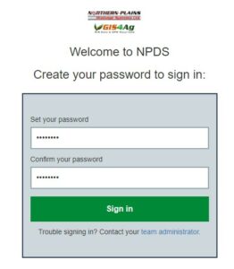
In future, navigate to https://mangomap.com/npds/sign-in and sign in with your email and password
Open the Map Portal(s) you have access to from here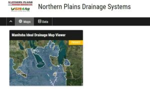
2. View Detailed Elevation & Drainage Info for your Fields via the Portal on your PC, iPad, or Mac
Zoom and pan or use the Search tool to search by land location to locate your field(s).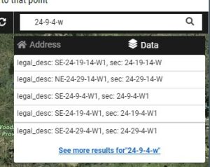
Analyze information, create customized prints or PDF map views, and create + print custom sketches (ideal for documenting proposals for permitting). Accessing the Portal on a mobile device (iPhone or Android) you can also use geolocation to see your location on the map - just be sure to run Google Maps or similar in the background to force the GPS to stay on rather than using cell towers for location!
3. Download Data into Ditch Assist
You’ll receive detailed email instructions with a URL to link the Ditch Assist App to IDM and contour data. With your tablet connected to the internet, just zoom and pan around your fields to download and cache the map layers. When you're in the field, easily recall the saved maps for accurate, real-time guidance.